I love having the same students from year to year (usually 6th-8th or 10th-12th, but sometimes I have them in 7th, 8th, and then again in 10th!). Daily routines are smoother and there’s no “boundary testing” each August. Not to mention not having to learn 100+ new names each year! On the other hand, this comes with a specific challenge: my kids can get (too) used to my activity styles so when I start seeing their eyes glaze over, or I find myself thinking, “I can’t handle another jigsaw this semester,” that’s when my new ideas lightbulb starts flashing.
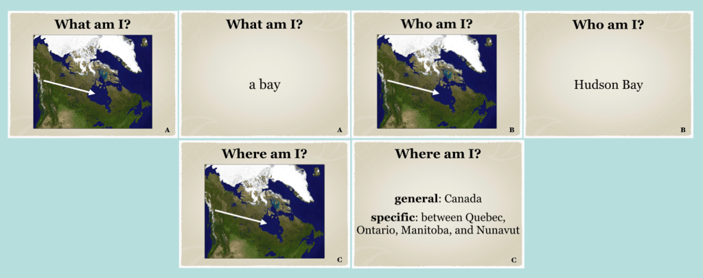
I recently needed a fresh way to review physical geography and that’s where this new game came from. It’s, “what am I, who am I, where am I.” Essentially, students have 3 chances to identify something they learned in the unit. They will look at an image and tell me: it’s a lake, it’s Lake Taupo, it’s in New Zealand, or all 3. Then they’ll write an identification or key fact for it. The images are a mix of satellite, locations on maps, and traditional pictures.
Here are 2 examples

I love this because it’s new for my kids and also because I have so much flexibility with how I implement it.
If I project it I can:
—use it as a whole class review
—group or pair students to compete (and they can pool their collective knowledge)
—for the “identification” part I can challenge my kids to come up with as many facts/pieces of information before moving on to the next image
If I print the images out I can:
—place the question slides around the room all jumbled up
—organize them according to who/what/where
—create a gallery walk according to region/landform type/or just go in the order the activity is already in
As an extension if time allows after the questions have been answered:
—if printed: students can rearrange the items according to region within the continent or specific country
—if printed: students can re-group the images according to type of landform
—if projected, the extensions can still be completed but students would write out their groupings in a chart or lists
—your kids make their own mini version of this activity with 5 items not included in the file and then can trade it with another group/pair/student
Regardless of method, for the “where” questions you can choose whether students need to identify the general and/or specific location (I’d recommend 1 point for general and 2 for specific).
If you think your students might respond well to this, I have sets for Asia, Africa, North America, South America, Central America, the Caribbean, the Middle East, Europe, and Australia/New Zealand/Oceania. Each set includes 2 examples slides for students, an answer recording sheet, the file as a PDF and PowerPoint, and a teacher information page (which also explains the letters in the bottom right corners). If you have questions about implementation you can reach me at stephanieshistorystore@gmail.com.
If you try this, let me know how your students (hopefully) enjoy it!
Categories: Teaching
